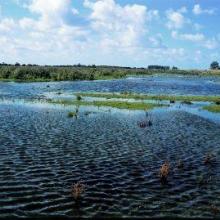
Haringvliet
- Pays:Pays-Bas (Royaume des)
- Numéro du site:1244
- Superficie:10'880 ha
- Date d’inscription:29-08-2000
- Coordonnées:51°47'N 04°07'E
Le matériel présenté sur ce site web, et en particulier les cartes et l’information territoriale, est tel qu’il apparaît dans les données disponibles et n’implique en aucune manière l’expression d’une opinion quelconque de la part du Secrétariat de la Convention de Ramsar concernant le statut juridique de tout pays, territoire, ville ou zone, ou de ses autorités, ou concernant la délimitation de ses frontières ou limites.
Panorama
Haringvliet is a closed inlet that forms part of the Rhine and Maas (Meuse) delta via an open connection with the Hollands Diep. In 2014, The Ramsar Site was aligned with the Natura 2000 site, resulting in an increase in its area of 152 hectares. The water level is artificially regulated and varies according to the supply from the Rhine. After the completion of the Haringvliet locks in 1970, the tide largely disappeared and the water turned from brackish to fresh. In an attempt to restore the original brackish condition and enable fish migration, the locks have been partly opened since 2019. The Site regularly supports more than 20,000 wintering waterbirds and nationally endangered and vulnerable species such as avocet, Eurasian spoonbill (Platalea leucorodia) and sandwich tern (Thalasseus sandvicensis). It also plays an important role as spawning, nursery and feeding ground for many fish, and supports nationally endangered molluscs. Human activities include commercial fishing, agriculture, shipping, reed cutting, angling, recreation and tourism. There is a visitors’ centre at Tiengemeten Island. Potential threats to the Site’s ecological character include an increase in tourism activities, urbanization, industrialization, unsustainable water management and eutrophication.
Région administrative:
Zuid-Holland
- Inscription légale nationale:
- National Ecological Network (NEN) - Haringvliet
- Inscriptions juridiques régionales (internationales):
- UE Natura 2000
- Date de dernière publication:01-11-2022
Téléchargements
Fiche descriptive Ramsar (FDR)
FDR archivées
Carte du site
Rapports et documents complémentaires
- Plan de gestion du site
