Search results
Search found 26 Ramsar Sites covering 1,176,952 ha
- (-) Remove Region/country: Oceania filter Region/country: Oceania
- (-) Remove Ramsar criteria: 3 filter Ramsar criteria: 3
- (-) Remove Ramsar criteria: 1 filter Ramsar criteria: 1
- (-) Remove Wetland type: Inland wetlands filter Wetland type: Inland wetlands
- (-) Remove Transboundary Site: No filter Transboundary Site: No
- (-) Remove Ramsar criteria: 2 filter Ramsar criteria: 2
- (-) Remove Region/country: Africa filter Region/country: Africa
- (-) Remove Wetland type: Va: Montane wetlands filter Wetland type: Va: Montane wetlands
- (-) Remove Region/country: Europe filter Region/country: Europe
Map
Materials presented on this website, particularly maps and territorial information, are as-is and as-available based on available data and do not imply the expression of any opinion whatsoever on the part of the Secretariat of the Ramsar Convention concerning the legal status of any country, territory, city or area, or of its authorities, or concerning the delimitation of its frontiers or boundaries.
List
-


Black Bog
-
Country:Ukraine
-
Designation date:20-03-2019
-
Site number:2389
-
Published since:4 year(s)
15 ha -
-


Blue Lake
-
Country:Australia
-
Designation date:17-03-1996
-
Site number:800
-
Published since:1 year(s)
338 ha -
-

Estrela Mountain upper Plateau and upper Zêzere River
-
Country:Portugal
-
Designation date:02-12-2005
-
Site number:1614
-
Published since:18 year(s)
5,075 ha -
-


Havmyran
-
Country:Norway
-
Designation date:06-08-2002
-
Site number:1190
-
Published since:6 year(s)
3,872 ha -
-
Humedales del Macizo de Peñalara
-
Country:Spain
-
Designation date:19-02-2007
-
Site number:1673
-
Published since:17 year(s)
487 ha -
-


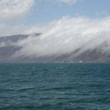


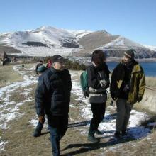

Lake Sevan
-
Country:Armenia
-
Designation date:07-06-1993
-
Site number:620
-
Published since:13 year(s)
490,231 ha -
-


")


")


Lets'eng-la-Letsie
-
Country:Lesotho
-
Designation date:01-07-2004
-
Site number:1388
-
Published since:18 year(s)
434 ha -
-

Møsvasstangen
-
Country:Norway
-
Designation date:18-03-1996
-
Site number:803
-
Published since:6 year(s)
1,441 ha -
-
Natal Drakensberg Park
-
Country:South Africa
-
Designation date:21-01-1997
-
Site number:886
-
Published since:27 year(s)
242,813 ha -
-

Nationalpark Kalkalpen
-
Country:Austria
-
Designation date:02-02-2004
-
Site number:1371
-
Published since:20 year(s)
18,532 ha -