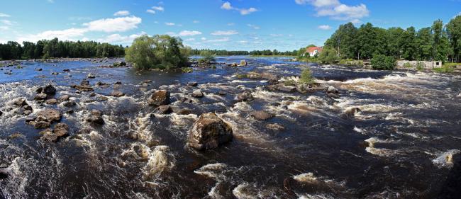
Färnebofjärden
Färnebofjärden
- Country:
- Sweden
- Site number:
- 1116
- Area:
- 16,866.0 ha
- Designation date:
- 14-11-2001
- Coordinates:
- 60°13'02"N 16°48'55"E
Carousel
CarouselMaterials presented on this website, particularly maps and territorial information, are as-is and as-available based on available data and do not imply the expression of any opinion whatsoever on the part of the Secretariat of the Ramsar Convention concerning the legal status of any country, territory, city or area, or of its authorities, or concerning the delimitation of its frontiers or boundaries.
Färnebofjärden, previously known as Dalälven-Färnebofjärden, includes Färnebofjärden National Park and Gysinge and Ålbo Nature Reserves. The River Dalälven runs in a flat and open landscape, where it widens and forms a series of broad and shallow lakes. Short, often multi-branched rapids separate the lakes. It is a rare example in the European Boreal region of a near-natural river system with regular flooding. Its important habitats include alluvial forests, exposed river bottoms with fine-grained soils, rapids and open fens along the river. The unexploited rapids, along with the limited forestry and small human population in the immediate vicinity of the Site, give an impression of untouched wilderness. Situated at the transition between the vegetation types of northern and southern Sweden, the Site has a rich diversity of mires, riverside meadows, birch and alder fens, marsh meadows, peat bogs, and shore fens. Flooding is common, and flood control is an important function of the Site. The fauna is diverse, from the many birds and fish species, to the largest population in Sweden of the mosquito Aedes rossicus. Because of the wilderness character of the area, and its fauna and landscape, it is well known for birdwatching, hiking, canoeing, and fishing.
Administrative region:
Four counties: Västmanland, Gävleborg, Uppsala and Dalarna
Global international designation:
- UNESCO Biosphere Reserve
National legal designation:
- National Park - Färnebofjärdens nationalpark
- Natura 2000 SCI - Östa SE0210369
- Natura 2000 SCI and SPA (1a) - Färnebofjärden syd SE0210368 (in the county of Uppsala)
- Natura 2000 SCI and SPA (1b) - Färnebofjärden syd SE0210368 (in the county of västmanland)
- Natura 2000 SCI and SPA (2) - Ista SE0630191
- Natura 2000 SCI and SPA (3) - Färnebofjärden SE0630190
- Natura 2000 SCI and SPA (4) - Gysinge SE0630192
- Natura 2000 SCI and SPA (5) - Övre Hedesundafjärden SE0630189
- Natura 2000 SCI and SPA (6) - Jordbärsmuren-Ålbo SE0630153
- Natura 2000 SCI and SPA (7) - Pellesberget SE0210367
- Natura 2000 SCI and SPA (8) - Färnebofjärden nordväst SE0620234
- Natura 2000 SPA (1) - Hedesunda SE0630186
- Natura 2000 SPA (2) - Hedesundafjärden SE0210366
- Nature reserve (1) - Jordbärsmuren-Ålbo
- Nature reserve (2) - Gysinge
- Nature reserve (3) - Ista
- Nature reserve (4) - Hedesundafjärden
- Nature reserve (5) - Östa
Regional (international) legal designations:
- EU Natura 2000
Last publication date:
31-03-2017
Ramsar Information Sheet (RIS)
- SE1116RIS_1703_en.pdf
- SE1116RISformer_150218.pdf
- SE1116_map1503.pdf
- SE1116_mgt1508.pdf
Archived RIS
Site map
Additional reports and documents
Site management plan
Other published literature


