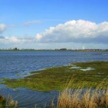
Hollands Diep
- Country:Netherlands (Kingdom of the)
- Site number:1273
- Area:4,139 ha
- Designation date:29-08-2000
- Coordinates:51°42'N 04°30'E
Materials presented on this website, particularly maps and territorial information, are as-is and as-available based on available data and do not imply the expression of any opinion whatsoever on the part of the Secretariat of the Ramsar Convention concerning the legal status of any country, territory, city or area, or of its authorities, or concerning the delimitation of its frontiers or boundaries.
Overview
This freshwater lake used to be a brackish estuary in the Rhine and Maas (Meuse) delta but was separated from the North Sea in 1970 by the Haringvliet dam. In 2014 the Site was aligned with the Natura 2000 site, resulting in an increase in its area of 74 hectares. Hollands Diep is an especially important area for breeding waterbirds such as the Eurasian spoonbill (Platalea leucorodia) and barnacle goose (Branta leucopsis), and a valuable spawning, nursery and feeding ground for national threatened fish species such as barbel (Barbus barbus) and other migratory fish including silver salmon (Salmo salar). The Site plays an important role in flood regulation and sediment trapping. The lake and the adjacent land are used for forestry, farming, commercial fishing, shipping, water management, conservation and research. Factors adversely affecting the Site’s ecological character include industrialization, urbanization and pollution leading to eutrophication.
Administrative region:
Zuid-Holland
- National legal designation:
- National Ecological Network (NEN) - Hollands Diep
- Regional (international) legal designations:
- EU Natura 2000
- Last publication date:01-11-2022
Downloads
Ramsar Information Sheet (RIS)
Archived RIS
Site map
Additional reports and documents
- Site management plan
