Le Marais audomarois
Le Marais audomarois
- Country:
- France
- Site number:
- 1835
- Area:
- 3,726.0 ha
- Designation date:
- 15-09-2008
- Coordinates:
- 50°46'53"N 02°15'38"E
Carousel
Carousel


Materials presented on this website, particularly maps and territorial information, are as-is and as-available based on available data and do not imply the expression of any opinion whatsoever on the part of the Secretariat of the Ramsar Convention concerning the legal status of any country, territory, city or area, or of its authorities, or concerning the delimitation of its frontiers or boundaries.
Cultural and natural heritage have mixed for the past 13 centuries in this unique human-made complex of marshes, peat bogs and meadows, which supports high biodiversity within a very urbanized and densely populated area. 56,000 people live in the municipalities that make up the marsh, including around 100 families who live on islands. These communities have been able to cultivate and live in the Site by building 700 kilometres of canals, drainage channels and hydraulic systems to control water levels. The Site hosts one third of the aquatic plant species found in France, and it also supports different life history stages of 26 fish species including the critically endangered European eel (Anguilla anguilla). Among 13 bat species, Myotis dasycneme, the rarest bat in France, is regularly found here during its reproduction period. The Site is an important staging area for the vulnerable aquatic warbler (Acrocephalus paludicola) and threatened breeding birds such as the western marsh harrier (Circus aeruginosus). The Site is important for fresh water supply as well for recreation and nature observation. Its urbanized nature and the surrounding intensive agiculture present challenges to its management. It serves a valuable role in flood control; floodwaters from the Aa river basin pass through, but it is only two metres above sea level and so outflow is complex and gradual. The Site is thus itself threatened by intense rains and seawater incursions in a context of a warming climate.
- UNESCO Biosphere Reserve
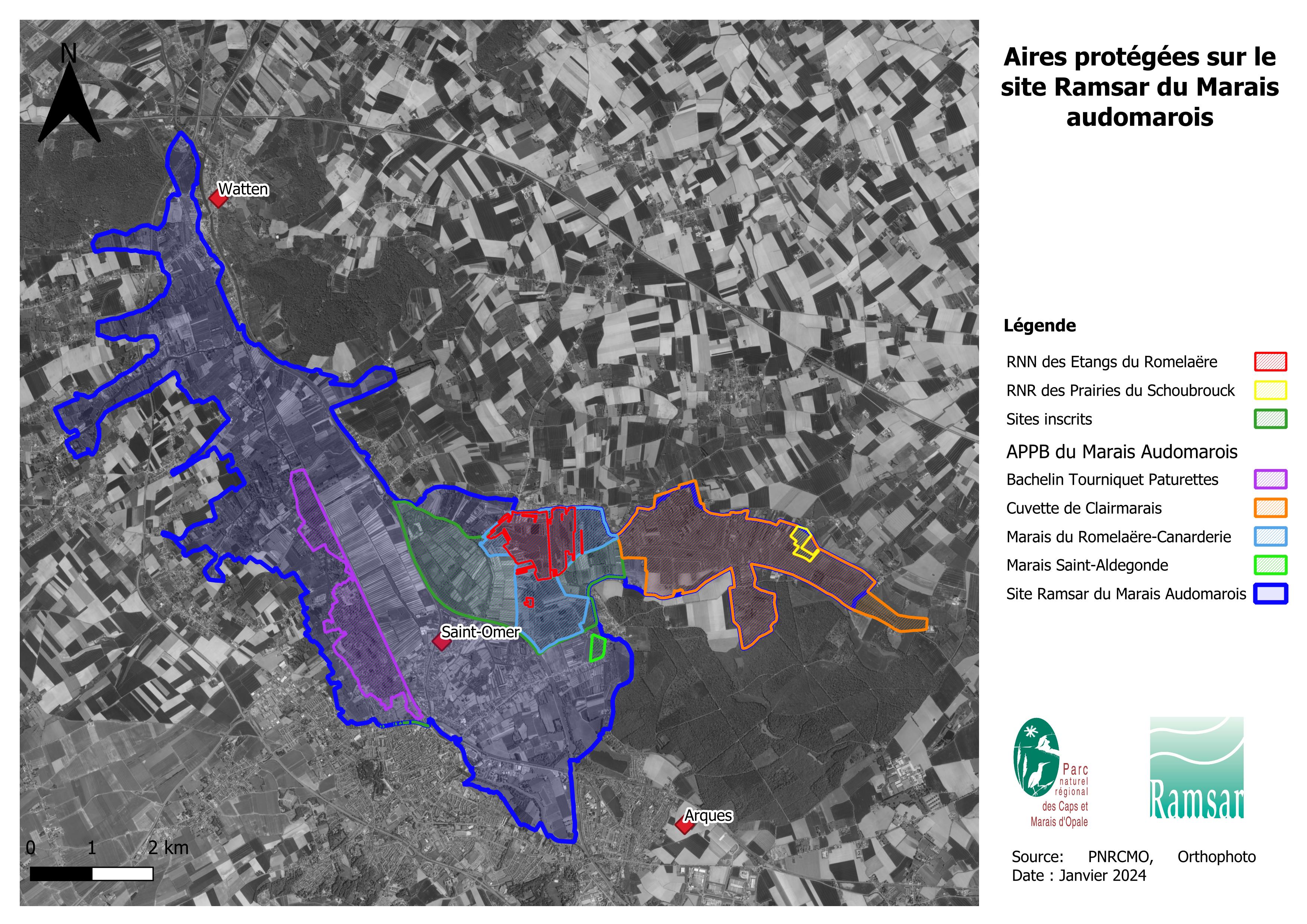
- Arrêté Préfectoral de Protection de Biotope - La cuvette de Clairmarais, Nieurlet et Noordpeene
- Arrêté Préfectoral de Protection de Biotope - Le Romelaëre et le marais de Booneghem et de la Canarderie
- Arrêté Préfectoral de Protection de Biotope - Le marais Sainte Aldegonde
- Arrêté Préfectoral de Protection de Biotope - le marais du Bachelin-Tourniquet
- Réserve Naturelle Nationale - Etangs du Romelaëre
- Réserve Naturelle Régionale - Les Prairies du Schoubrouck
- EU Natura 2000
- FR1835RIS_2412_fr.pdf
- FR1835RISformer_150323.pdf
- FR1835RISformer_231005_1712_fr.pdf
- FR1835map_add.pdf
- FR1835map_over.pdf
- FR1835_map240515.jpeg
- FR1835_map240515_1.jpeg
- FR1835_taxo240618.pdf
- FR1835_mgt170731.pdf