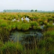
Groote Peel
- Country:Netherlands (Kingdom of the)
- Site number:192
- Area:1,348 ha
- Designation date:23-05-1980
- Coordinates:51°20'N 05°49'E
Materials presented on this website, particularly maps and territorial information, are as-is and as-available based on available data and do not imply the expression of any opinion whatsoever on the part of the Secretariat of the Ramsar Convention concerning the legal status of any country, territory, city or area, or of its authorities, or concerning the delimitation of its frontiers or boundaries.
Overview
The Site supports rich vegetation in a landscape characterized by marshland raised bog, pools, channels, heathland and pine plantations with artificially maintained water levels. In 2014, the boundary of the Ramsar Site was aligned with the Natura 2000 site, resulting in an increase in area of 22 hectares. It is an important breeding area for waterbirds, and particularly known as the most important resting place in the Netherlands of migrating common cranes (Grus grus). Groote Peel plays an important role in groundwater replenishment and carbon sequestration as well as water management. The Site is used for farming, forestry and tourism. The management measures have restored the water levels, resulting in a substantial regeneration of peat moss species. There is a visitors’ centre, and boardwalks make the Site more accessible.
Administrative region:
Noord-Brabant and Limburg
- National legal designation:
- National Ecological Network (NEN) - Groote Peel
- National Park - Groote Peel
- Regional (international) legal designations:
- EU Natura 2000
- Last publication date:02-11-2022
Downloads
Ramsar Information Sheet (RIS)
Archived RIS
Site map
Additional reports and documents
- Site management plan
