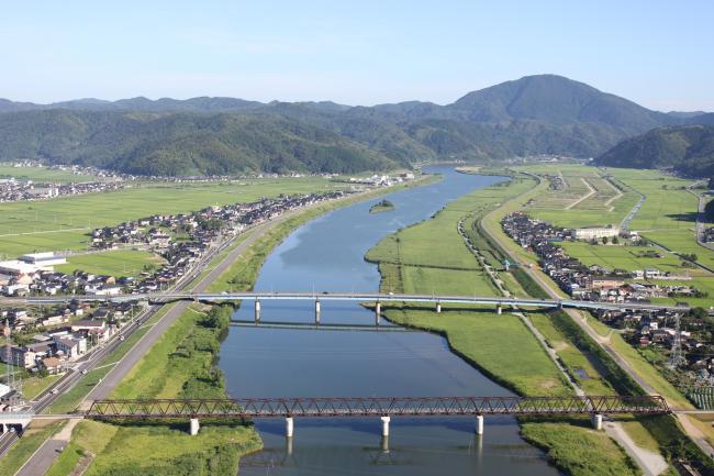
Lower Maruyama River and the Surrounding Rice Paddies
Lower Maruyama River and the Surrounding Rice Paddies
- Country:
- Japan
- Site number:
- 2055
- Area:
- 1,094.0 ha
- Designation date:
- 03-07-2012
- Coordinates:
- 35°36'39"N 134°50'23"E
Carousel
CarouselMaterials presented on this website, particularly maps and territorial information, are as-is and as-available based on available data and do not imply the expression of any opinion whatsoever on the part of the Secretariat of the Ramsar Convention concerning the legal status of any country, territory, city or area, or of its authorities, or concerning the delimitation of its frontiers or boundaries.
The Site consists of various types of wetland including the estuary of the Maruyama River, which stretches more than 16 kilometres inland, the surrounding rice paddies, the constructed Toshima Wetland, and the Kaya Wetland which was constructed as part of a natural area restoration project. It is famous for the successful reintroduction since 1955 of the endangered oriental white stork (Ciconia boyciana), after the species had become extinct in the biogeographic region. The stork population in and around the Site has been increasing, with the storks using the surrounding area as foraging and nesting grounds. Accordingly, the Site has been extended from 560 to 1,094 hectares to ensure better protection of the species. The diverse wetlands provide an ideal spawning and nursery habitat for a variety of fish, including threatened species such as the globally endangered Japanese eel (Anguilla japonica), the nationally vulnerable northern medaka (Oryzias sakaizumii) and the fourspine sculpin (Cottus kazika). The Site is also a suitable habitat for the black-spotted pond frog (Pelophylax nigromaculatus) and the Japanese weatherfish (Misgurnus anguillicaudatus), which the storks eat. The people in Toyooka City rely on the lower Maruyama River for water for domestic, industrial and agricultural use and as a source of food through its fisheries.
- Other global designation
- Class A River (Specified waterways of special importance protected by the government ) - Maruyama River, Maruyama River Water System
- National Park - San’inkaigan National Park
- National Wildlife Protection Area - Lower Maruyama River National Wildlife Protection Area
- Special Protection Zone of National Wildlife Protection Area - Lower Maruyama River Special Protection Zone
- JP2055RIS_1810_en.pdf
- JP2055RISformer_180815.pdf
- JP2055_map181003.pdf
