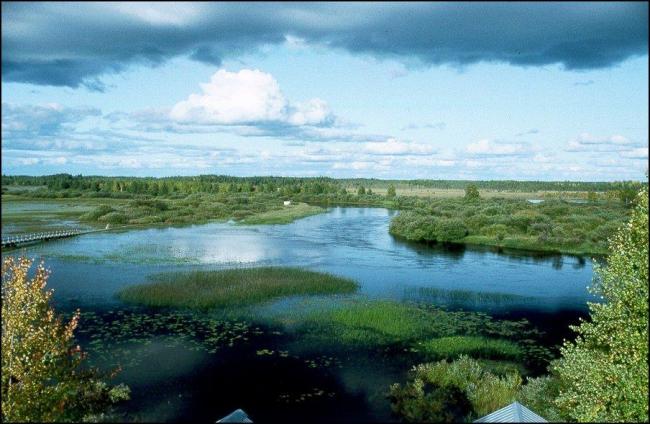
Sikåsvågarna
Sikåsvågarna
- Country:
- Sweden
- Site number:
- 2260
- Area:
- 2,305.0 ha
- Designation date:
- 29-01-2015
- Coordinates:
- 63°38'04"N 15°16'47"E
Carousel
CarouselMaterials presented on this website, particularly maps and territorial information, are as-is and as-available based on available data and do not imply the expression of any opinion whatsoever on the part of the Secretariat of the Ramsar Convention concerning the legal status of any country, territory, city or area, or of its authorities, or concerning the delimitation of its frontiers or boundaries.
Located along the Sikåsån stream, Sikåsvågarna consists of large topogenous calcareous fens, wooded mires, wetland forest, meandering streams, small pools and a delta formed where the stream flows into Lake Hammerdalssjön. The Site provides breeding grounds for several birds including the western marsh harrier Circus aeruginosus and the common crane Grus grus. The natural water regime of the river supports important migration paths, nursery and foraging grounds for several fish species including brown trout Salmo trutta. Significant transportation and deposition of sediments takes place within the Site as erosion occurs in the meandering bows of the Sikåsån stream and sediments are then deposited further downstream in the recent delta in Hammerdalssjön Lake. Human activities include hunting, fishing and cloudberry picking. A birdwatching tower is placed near the stream. The main factors affecting the ecological character of the Site relate to logging and wood harvesting. A conservation plan for the Natura 2000 Site is implemented on the Site.
Administrative region:
Jämtland county
National legal designation:
- Protected against building hydro-electric dams - Ammerån
Regional (international) legal designations:
- EU Natura 2000
Last publication date:
22-04-2016
Ramsar Information Sheet (RIS)
- SE2260RIS_1603_en.pdf
Site map
