Bassin de la Lufira
Bassin de la Lufira
- Country:
- Democratic Republic of the Congo
- Site number:
- 2318
- Area:
- 4,470,993.2 ha
- Designation date:
- 31-10-2017
- Coordinates:
- 09°20'57"S 26°54'51"E
Carousel
CarouselMaterials presented on this website, particularly maps and territorial information, are as-is and as-available based on available data and do not imply the expression of any opinion whatsoever on the part of the Secretariat of the Ramsar Convention concerning the legal status of any country, territory, city or area, or of its authorities, or concerning the delimitation of its frontiers or boundaries.
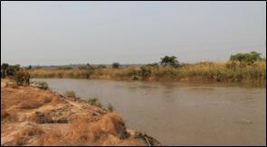
The vast Site in the south-east of the country consists of rivers and their floodplains, natural and artificial lakes and ponds, waterfalls, papyrus and other marshes, and marshy forests. The main river feeding it is the Lufira. The prevailing soil and climatic factors ensure the maintenance of the Site’s unique biological diversity. Many endemic species are present: 16 bird species including the Lufira masked weaver, the Upemba masked weaver and the black-faced waxbill; 15 reptile species including the Upemba mud turtle, the lined water snake and the Mulanje water snake; and at least two endemic amphibians, the Katanga thick-toed gecko and the frog Afrixalus upembae. The Lufira Basin remains the only biotope for rare mammals such as the Grant’s zebra and the greater kudu, and it is also home to populations of giant sable and roan antelope. The lack of control and regulation of mining activities and the related hydrometallurgical treatment plants presents a real threat to the Site.
- UNESCO Biosphere Reserve
- Domaine de chasse de Lubudi Sampwe
- Domaine de chasse de Mulumbu
- Domaine de chasse du plateau des Kundelungu
- Parc National de l’Upemba
- Parc National des Kundelungu
- Réserve du lac Tshangalele (domaine de chasse)
- CD2318RIS_1711_fr.pdf
- CD2318_map1512.pdf
- CD2318_map15121.pdf
- CD2318_map15122.pdf


