Rio Negro
Rio Negro
- Country:
- Brazil
- Site number:
- 2335
- Area:
- 12,001,614.4 ha
- Designation date:
- 19-03-2018
- Coordinates:
- 01°43'44"S 64°05'19"W
Carousel
Carousel


Materials presented on this website, particularly maps and territorial information, are as-is and as-available based on available data and do not imply the expression of any opinion whatsoever on the part of the Secretariat of the Ramsar Convention concerning the legal status of any country, territory, city or area, or of its authorities, or concerning the delimitation of its frontiers or boundaries.
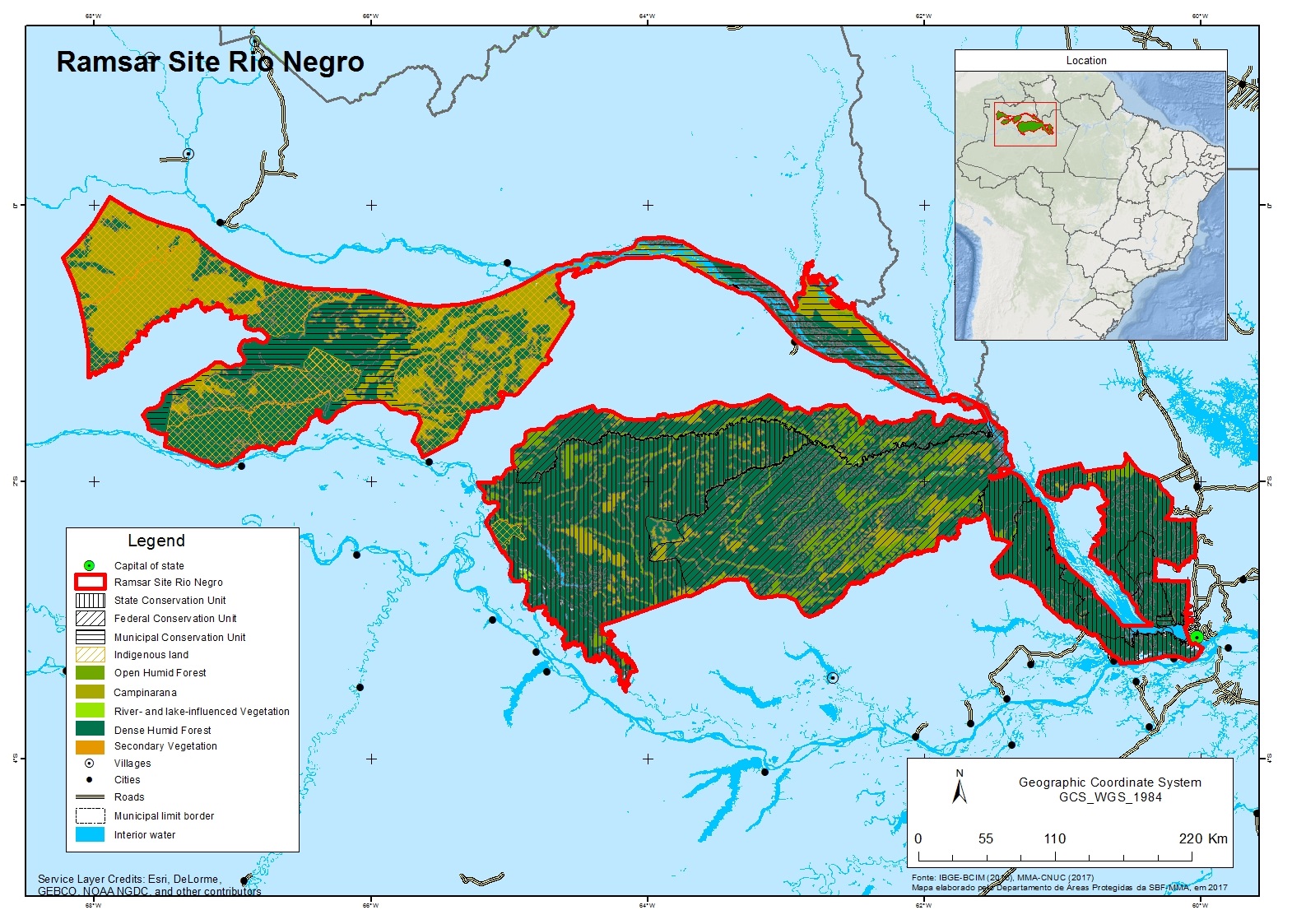
Rio Negro, covering over 12 million hectares, is part of the largest tributary river on the north side of the Amazon basin and includes more than 20 conservation units and indigenous lands. Lying at the core of one of the largest preserved tropical rainforests on the planet, the Site includes several ecosystems particular to the region, such as Igapó (blackwater-flooded) forests, edaphic savannas, and fluvial archipelagos. Rio Negro’s rich biodiversity encompasses globally threatened animal species such as the ash-breasted antbird (Myrmoborus lugubris), the giant river otter (Pteronura brasiliensis), the critically endangered Brazilian barefaced tamarin (Saguinus bicolor), the white-bellied spider monkey (Ateles belzebuth), and plants such as the Brazil nut (Bertholletia excelsa). The local communities inhabiting the Site are ethnically and culturally diverse, with the conservation units intended to support their sustainable forms of resource use and low-impact agriculture. The Site also contributes to the water supply of at least six Brazilian municipalities, with the main river channel serving as a waterway connecting communities. Among the main threats to the Site are land conversion and clearance of vegetation, as well as uncontrolled hunting and fishing.
- UNESCO Biosphere Reserve
- World Heritage site
- Indigenou land - Alto Rio Negro Indigenou land
- conservation unit - Parque Estadual Rio Negro Setor Norte
- conservation unit - Parque Estadual Rio Negro Setor Sul
- conservation unit - Parque Nacional do Jaú
- conservation unit - Reserva Extrativista do Rio Unini
- conservation unit - Reserva Particular do Patrimônio Natural Ilhas Alexandre Rodrigues Ferreira
- conservation unit - Reserva de Desenvolvimento Sustentável Amanã
- conservation unit - Reserva de Desenvolvimento Sustentável Puranga Conquista
- conservation unit - Reserva de Desenvolvimento Sustentável do Rio negro
- conservation unit - Reserva de Desenvolvimento Sustentável do Tupé
- conservation unit - Área de Proteção Ambiental Jufari
- conservation unit - Área de Proteção Ambiental Margem Direita do Rio Negro-Setor Paduari-Solimões
- conservation unit - Área de Proteção Ambiental Margem Esequerda do Rio Negro-Setor Tarumã Açu-Tarumã Mirima
- conservation unit - Área de Proteção Ambiental Margem Esquerda do Rio Negro-Setor Aturiá-Apuauzinho
- conservation unit - Área de Proteção Ambiental Mariua
- conservation unit - Área de Proteção Ambiental Municipal Tapuruquara
- conservation unit - Área de Proteção Ambiental Taruma/Ponta Negra
- conservation unit - Área de Relevante Interesse Ecológico Projeto Dinâmica Biológica de Fragmentos Florestais
- indigenous land - Cuiu-Cuiu indigenous land
- indigenous land - Jurubaxi-Téa indigenous land
- indigenous land - Maraã Urubaxi indigenous land
- indigenous land - Médio Rio Negro I indigenous land
- indigenous land - Parana do Boa Boa indigenous land
- indigenous land - Rio Téa indigenous land
- indigenous land - Uneiuxi indigenous land
- BR2335RIS_2109_en.pdf
- BR2335RISformer_200218_1806_en.pdf
- BR2335_map180224.jpg